Activity: Watch video : www.youtube.com/watch?v=v1-HFWpKqls and send comments to ima.monserrat@gmail.com with the title GPS and your name and group.
What are satellite photographs?
Satellite
photographs are a type of photograph used by geographers.
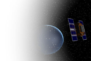
Satellite
photographs are images of the Earth's surface. The information for these images
is captured and transmitted using specialised cameras, scanners or sensors
which are fitted to an artificial satellite (ie not moons or stars). These
man-made satellites orbit the Earth from a distance of up to 1000 kilometres
above the surface.

In
1960, the first satellite photographs of the Earth were created by a weather
satellite. This was less than a year after the first satellite images of the
moon were captured. Since then, satellite images have been used for a wide
variety of purposes. Owing to satellite photographs being able to show cloud
patterns with great clarity, they are often seen on television as a part of the
weather forecast. Popular action movies and television programs have also made
satellite imagery synonymous with military and government intelligence and
security agencies. Satellite imagery is also used in the fields of cartography
(creating maps of the Earth's surface) geology, engineering, oceanography
(scientific study of the ocean) and agriculture.

Advantages
and disadvantages
One
main advantage of satellite imagery is that it can show a large area. While
oblique and aerial photographs may have a scale in which one centimetre on the
page represents a few hundred metres on the ground, satellite images can
represent tens of kilometres in a single centimetre.
Satellite
images can also provide more information than conventional photographs.
Scanners and sensors not only show vegetation and settlement patterns, but also
make measurements of the Earth's surface and detect different frequencies of electromagnetic radiation.
Collected information ranges from the amount of water vapour in the atmosphere,
to the temperature of the land and sea.
Although
satellite imagery is very useful, it does have some downfalls. Satellite
imagery is time consuming, since it takes a long time to process the large
pictures using such a high resolution. To create an adequate image from space,
optimum conditions are also required. Weather patterns can be unpredictable and
the sun, which is the major source of light, needs to be in an ideal position.
If the conditions are not optimum, it may be days or even weeks until the
satellite will return to the area which is required to be photographed.
What is GPS?
The Global Positioning System (GPS) is a satellite-based navigation system made up of a network of 24 satellites placed into orbit by the U.S. Department of Defense. GPS was originally intended for military applications, but in the 1980s, the government made the system available for civilian use. GPS works in any weather conditions, anywhere in the world, 24 hours a day.
How it works
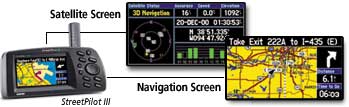 GPS satellites circle the earth twice a day in a very precise orbit and transmit signal information to earth. GPS receivers take this information and use triangulation to calculate the user's exact location. Essentially, the GPS receiver compares the time a signal was transmitted by a satellite with the time it was received. The time difference tells the GPS receiver how far away the satellite is.The receiver can determine the user's position and display it on the unit's electronic map. GPS allows people to determine the time and their speed anywhere in the world.
A GPS receiver must be locked on to the signal of at least three satellites to calculate a 2D position (latitude and longitude) and track movement. With four or more satellites in view, the receiver can determine the user's 3D position (latitude, longitude and altitude). Once the user's position has been determined, the GPS unit can calculate other information, such as speed, bearing, track, trip distance, distance to destination, sunrise and sunset time and more.
How accurate is GPS?
Today's GPS receivers are extremely accurate, thanks to their parallel multi-channel design. Garmin's 12 parallel channel receivers are quick to lock onto satellites when first turned on and they maintain strong locks, even in dense foliage or urban settings with tall buildings. Certain atmospheric factors and other sources of error can affect the accuracy of GPS receivers. Garmin® GPS receivers are accurate to within 15 meters on average.
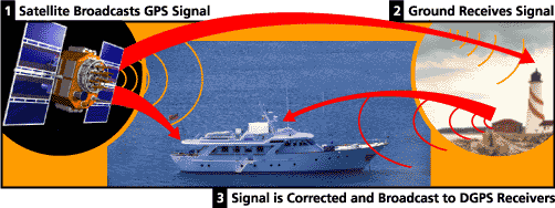
Newer Garmin GPS receivers with WAAS (Wide Area Augmentation System) capability can improve accuracy to less than three meters on average. No additional equipment or fees are required to take advantage of WAAS. Users can also get better accuracy with Differential GPS (DGPS), which corrects GPS signals to within an average of three to five meters. The U.S. Coast Guard operates the most common DGPS correction service. This system consists of a network of towers that receive GPS signals and transmit a corrected signal by guide transmitters. In order to get the corrected signal, users must have a differential guide receiver and guide antenna in addition to their GPS.
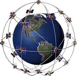
The GPS satellite system
The 24 satellites that make up the GPS space segment are orbiting the earth about 12,000 miles above us. They are constantly moving, making two complete orbits in less than 24 hours. These satellites are travelling at speeds of roughly 7,000 miles an hour.
GPS satellites are powered by solar energy. They have backup batteries onboard to keep them running in the event of a solar eclipse, when there's no solar power. Small rocket boosters on each satellite keep them flying in the correct path.
Here are some other interesting facts about the GPS satellites (also called NAVSTAR, the official U.S. Department of Defense name for GPS).
What Is GIS?
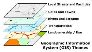
Maps have been used for thousands of years, but it is only within the last few decades that the technology has existed to combine maps with computer graphics and databases to create geographic information systems or GIS. The themes in the above graphic are only a small example of the wide array of information that can view or analyze with a GIS. GIS is used to display and analyze spatial data which are tied to databases. This connection is what gives GIS its power: maps can be drawn from the database and data can be referenced from the maps. When a database is updated, the associated map can be updated as well. GIS databases include a wide variety of information including: geographic, social, political, environmental, and demographic. GIS uses layers , called "themes," to overlay different types of information, much as some static maps use mylar overlays to add tiers of information to a geographic background. GIS is a series of overlapped maps.Each theme represents a category of information, such as roads or forest cover. As with the old mylar maps, the layers which are underneath remain visible while additional themes are placed above.
How GIS Works
It is estimated that approximately 80% of all information has a "spatial" or geographic component. In other words, most information is tied to a place. So when making decisions about siting new facilities, creating hiking trails, protecting wetlands, directing emergency response vehicles, designating historic neighborhoods or redrawing legislative districts, geography plays a significant role. This is where GIS comes in. Geographic Information Systems (GIS) technology is a computer-based data collection, storage, and analysis tool that combines previously unrelated information into easily understood maps. But GIS is much more than maps. A GIS can perform complicated analytical functions and then present the results visually as maps, tables or graphs, allowing decision-makers to virtually see the issues before them and then select the best course of action. Add the Internet, and GIS offers a consistent and cost-effective means for the sharing and analysis of geographic data among government agencies, private industry, non-profit organizations, and the general public.
Useful Link:
http://gispathway.com/2008/10/21/teaching-kids-the-world-of-gis/