After reading and taking notes or printing please go to the following link to illustrate your work (if images here are too small) and do practice activities :).
http://www.learner.org/interactives/dynamicearth/index.html
Introduction
The earth — think it's solid as a rock?
Our planet might seem fixed and rigid, but a closer look reveals that it is constantly shifting under our feet.
Delve into the earth's interior, learn about its tectonic plates and their movements, and discover how mountains, volcanoes, and earthquakes are formed.


What's inside the earth?
In the early part of the 20th century, geologists studied the vibrations (seismic waves) generated by earthquakes to learn more about the structure of the earth's interior. They discovered that it is made up of these distinct layers: the crust, the mantle, and the core.
Plate Tectonics
Scientist Alfred Wegener In the early 1900s, the German scientist Alfred Wegener noticed that the coastlines of Africa and South America looked like they might fit together. He also discovered evidence that the same plant and animal fossils were found along the coasts of these continents, although they were now separated by vast oceans. In addition, he noticed that geologic formations, like mountain ranges, on the two continents also matched up. In 1915, Wegener published his book, The Origin of Continents and Oceans, suggesting that the earth's continents were once joined together in one large mass. He called the original landmass (or supercontinent) "Pangaea," the Greek word for "all the earth."
200 million years ago
|
135 million years ago
|
65 million years ago
|
50-40 million years ago
|
Pangaea
begins to break up and splits into two major landmasses — Laurasia in the
north, made up of North America and Eurasia, and Gondwana in the south, made
up of the other continents.
|
Gondwana
splinters further — the South America-Africa landmass separates from the
Antarctica-Australia landmass.
The Indian landmass breaks away from the Antarctica-Australia landmass. |
Major rifting
of Laurasia, with the North American landmass separating from Eurasia.
South America and Madagascar separate from Africa. |
Greenland
separates from North America.
Australia separates from Antarctica and moves north. The Indian landmass collides with Asia. |
According to Wegener, over time "Pangaea" split apart and the different landmasses, or continents, drifted to their current locations on the globe. While other scientists of the time vehemently rejected Wegener's ideas, they became the basis for the development of the theory of plate tectonics.
Continents on the Move
200 million years ago 135 million years ago 65 million years ago 50-40 million years ago
Pangaea begins to break up and splits into two major landmasses — Laurasia in the north, made up of North America and Eurasia, and Gondwana in the south, made up of the other continents. Gondwana splinters further — the South America-Africa landmass separates from the Antarctica-Australia landmass.
The Indian landmass breaks away from the Antarctica-Australia landmass. Major rifting of Laurasia, with the North American landmass separating from Eurasia.
South America and Madagascar separate from Africa. Greenland separates from North America.
Australia separates from Antarctica and moves north.
The Indian landmass collides with Asia.
The modern plate tectonics theory, which has become widely accepted since the 1960s, states that the earth's outer layer, or lithosphere, is broken into several large slabs called plates. These plates, which hold the continents and oceans, are slowly but constantly moving around the planet.
 The movement of the plates not only supports our understanding that continents are not fixed and moved over time, but also explains how and why earthquakes, volcanoes, and other geologic events occur.
Plates & Boundaries
The earth's continents are constantly moving due to the motions of the tectonic plates. Closely examine the map below, which shows the 15 major tectonic plates.
As you can see, some of the plates contain continents and others are mostly under the ocean. The type of crust that underlies the continents is called continental crust, while the type found under the oceans is called oceanic crust. Continental crust is thicker — about 20 to 40 miles (35 to 70 km) thick — and usually older than oceanic crust, which is only 4 to 6 miles (7 to 10 km) thick. All the plates have names, usually referring to landmasses, oceans, or regions of the globe where they are located.
The border between two tectonic plates is called a boundary. All the tectonic plates are constantly moving — very slowly — around the planet, but in many different directions. Some are moving toward each other, some are moving apart, and some are sliding past each other. Because of these differences, tectonic plate boundaries are grouped into three main types.
The movement of the plates not only supports our understanding that continents are not fixed and moved over time, but also explains how and why earthquakes, volcanoes, and other geologic events occur.
Plates & Boundaries
The earth's continents are constantly moving due to the motions of the tectonic plates. Closely examine the map below, which shows the 15 major tectonic plates.
As you can see, some of the plates contain continents and others are mostly under the ocean. The type of crust that underlies the continents is called continental crust, while the type found under the oceans is called oceanic crust. Continental crust is thicker — about 20 to 40 miles (35 to 70 km) thick — and usually older than oceanic crust, which is only 4 to 6 miles (7 to 10 km) thick. All the plates have names, usually referring to landmasses, oceans, or regions of the globe where they are located.
The border between two tectonic plates is called a boundary. All the tectonic plates are constantly moving — very slowly — around the planet, but in many different directions. Some are moving toward each other, some are moving apart, and some are sliding past each other. Because of these differences, tectonic plate boundaries are grouped into three main types.


Slip, Slide, & Collide
Red-hot lava and plumes of ash spew out of a volcano in the Philippines. An undersea earthquake in the Indian Ocean spawns a tsunami that crashes into Indonesia. The Himalayan Mountains grow taller every year. Many of the most dramatic geological phenomena we experience on Earth — volcanic eruptions, earthquakes, tsunamis, and more — are caused by the slipping, sliding, and colliding of tectonic plates. As you might expect by now, most major geologic events occur at the boundaries between tectonic plates, where huge, massive pieces of the earth's crust interact. Each kind of plate boundary is associated with particular events, so if you know about the movements taking place at a plate boundary, you can often predict what's likely to occur there — volcanoes, earthquakes, mountains, trenches — in the future! Slip, Slide, & Collide Convergent Boundaries — Colliding Plates At convergent boundaries, tectonic plates collide with each other.
Red-hot lava and plumes of ash spew out of a volcano in the Philippines. An undersea earthquake in the Indian Ocean spawns a tsunami that crashes into Indonesia. The Himalayan Mountains grow taller every year. Many of the most dramatic geological phenomena we experience on Earth — volcanic eruptions, earthquakes, tsunamis, and more — are caused by the slipping, sliding, and colliding of tectonic plates. As you might expect by now, most major geologic events occur at the boundaries between tectonic plates, where huge, massive pieces of the earth's crust interact. Each kind of plate boundary is associated with particular events, so if you know about the movements taking place at a plate boundary, you can often predict what's likely to occur there — volcanoes, earthquakes, mountains, trenches — in the future! Slip, Slide, & Collide Convergent Boundaries — Colliding Plates At convergent boundaries, tectonic plates collide with each other.
The events that occur at these boundaries are linked to the types of plates — oceanic or continental — that are interacting.
Subduction Zones and Volcanoes
At some convergent boundaries, an oceanic plate collides with a continental plate. Oceanic crust tends to be denser and thinner than continental crust, so the denser oceanic crust gets bent and pulled under, or subducted, beneath the lighter and thicker continental crust. This forms what is called a subduction zone. As the oceanic crust sinks, a deep oceanic trench, or valley, is formed at the edge of the continent. The crust continues to be forced deeper into the earth, where high heat and pressure cause trapped water and other gasses to be released from it. This, in turn, makes the base of the crust melt, forming magma.
The magma formed at a subduction zone rises up toward the earth's surface and builds up in magma chambers, where it feeds and creates volcanoes on the overriding plate. When this magma finds its way to the surface through a vent in the crust, the volcano erupts, expelling lava and ash. An example of this is the band of active volcanoes that encircle the Pacific Ocean, often referred to as the Ring of Fire.
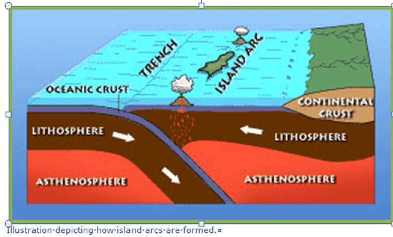
Illustration depicting how island arcs are formed.
A subduction zone is also generated when two oceanic plates collide — the older plate is forced under the younger one — and it leads to the formation of chains of volcanic islands known as island arcs. Examples include the Mariana Islands in the western Pacific Ocean and the Aleutian Islands, off the coast of Alaska.
Since the collision and subduction of plates is not a smooth process, large, powerful earthquakes are another phenomenon that result from this type of interaction.

Earthquakes generated in a subduction zone can also give rise to tsunamis. A tsunami is a huge ocean wave caused by a sudden shift on the ocean floor, such as an undersea earthquake. If the wave reaches land, it can cause incredible destruction, like the Asian Tsunami, which killed more than 200,000 people in 11 countries across the Indian Ocean region in December 2004.
Collision Zones and Mountains
What happens when two continental plates collide? Because the rock making up continental plates is generally lighter and less dense than oceanic rock, it is too light to get pulled under the earth and turned into magma. Instead, a collision between two continental plates crunches and folds the rock at the boundary, lifting it up and leading to the formation of mountains and mountain ranges.
Slip, Slide, & Collide Divergent Boundaries — Spreading Plates
At divergent boundaries, tectonic plates are moving away from each other. But if these huge masses of crust are moving apart, what happens in the space left between them?
Seafloor Spreading
Divergent boundaries in the middle of the ocean contribute to seafloor spreading. As plates made of oceanic crust pull apart, a crack in the ocean floor appears. Magma then oozes up from the mantle to fill in the space between the plates, forming a raised ridge called a mid-ocean ridge. The magma also spreads outward, forming new ocean floor and new oceanic crust.
Rifts
When two continental plates diverge, a valleylike rift develops. This rift is a dropped zone where the plates are pulling apart. As the crust widens and thins, valleys form in and around the area, as do volcanoes, which may become increasingly active. Early in the rift formation, streams and rivers flow into the low valleys and long, narrow lakes can be created. Eventually, the widening crust along the boundary may become thin enough that a piece of the continent breaks off, forming a new tectonic plate. At this point, water from the ocean will rush in, forming a new sea or ocean basin in the rift zone.


Transform Boundaries — Grinding Plates
At transform boundaries, tectonic plates are not moving directly toward or directly away from each other. Instead, two tectonic plates grind past each other in a horizontal direction. This kind of boundary results in a fault — a crack or fracture in the earth's crust that is associated with this movement.
Faults and Earthquakes
Transform boundaries and the resulting faults produce many earthquakes because edges of tectonic plates are jagged rather than smooth. As the plates grind past each other, the jagged edges strike each other, catch, and stick, "locking" the plates in place for a time. Because the plates are locked together without moving, a lot of stress builds up at the fault line. This stress is released in quick bursts when the plates suddenly slip into new positions. The sudden movement is what we feel as the shaking and trembling of an earthquake.
The motion of the plates at a transform boundary has given this type of fault another name — a strike-slip fault. The best-studied strike-slip fault is the San Andreas Fault in California. It is located at the boundary between the Pacific and North American plates and runs roughly 800 miles (1,300 km) through Northern and Southern California. As the two plates grind past each other — the Pacific Plate moving northwest and the North American Plate moving southeast — the motion produces numerous earthquakes along the fault. While many are small and cause only minor trembling, the San Andreas Fault has also been the site of major events: the 1857 Fort Tejon earthquake, the 1906 San Francisco earthquake and fire, and the 1989 Loma Prieta earthquake. Many scientists believe that the San Andreas Fault is due to unleash another large earthquake — a "big one" — in the coming decades.

1. Which of these layers is found directly above the earth's core?
a. Asthenosphere
b. Inner Core
c. Mantle
d. Outer Core
|
2. Which scientist is credited with
proposing the ideas that led to the development of the plate tectonics theory?
a. Charles Darwin
b. Albert Einstein
c. Isaac Newton
d. Alfred Wegener
|
 |
3. Mid-ocean ridges are places where
tectonic plates are doing what?
a. Colliding
b. Sliding past each other
c. Spreading apart
d. None of the above
|
4.What is happening at the subduction zone
of the Juan de Fuca and North American Plates?
a. Plates are sliding past each other.
b. Plates are spreading apart.
c. One plate is being pulled under another.
d. None of the above.
|
5. What type of crust is found under the
continents?
a. Continental crust
b. Oceanic crust
c. Geologic crust
d. None of the above
|
6. What is the name of this tectonic plate?
a. African Plate
b. Antarctic Plate
c. Arabian Plate
d. Indian Plate
|
 |
7. Mountain formation can result when which
of the following occurs?
a. Two oceanic plates collide.
b. Two continental plates collide.
c. Two oceanic plates spread apart.
d. None of the above..
|
8. California's San Andreas Fault is
identified as which of the following?
a. Blind thrust fault
b. Dip-slip fault
c. Normal fault
d. Strike-slip fault
|
9. Which of these statements is correct?
a. Continental crust is thicker than oceanic crust.
b. Continental crust is thinner than oceanic
crust.
c. Oceanic crust is thicker than continental crust.
d. Continental and oceanic crusts have the same
thickness.
|
10. Which of the following geologic events
can occur at a transform boundary?
a. Earthquake
b. Mountain formation
c. Volcanic eruption
d. Rift formation
|
11. When did the Himalayan Mountain Range
begin to form?
a. 5,000-6,000 years ago
b. 20-30 million years ago
c. 40-50 million years ago
d. 100-150 million years ago
|
12. Which of the earth's layers is broken
into several large tectonic plates?
a. Asthenosphere
b. Crust
c. Lithosphere
d. Outer Core
|
 |
13. What is the name of this tectonic plate?
a. Cocos Plate
b. Nazca Plate
c. Scotia Plate
d. South American Plate
|
 |
14. What is the earth's outermost layer?
a. Crust
b. Lithosphere
c. Mantle
d. Outer Core
|
 |
15. What leads to the creation of island
arcs?
a. Collision of two oceanic plates.
b. Collision of two continental plates.
c. Collision of a continental and an oceanic plate.
d. All of the above.
|
16.What type of crust is found under the
oceans?
a. Continental crust
b. Oceanic crust
c. Geologic crust
d. None of the above
|
17. When did the supercontinent Pangaea
start to break up?
a. 20 million years ago
b. 40 million years ago
c. 100 million years ago
d. 200 million years ago
|
 |
18. What kind of plate boundary is found at
the meeting point of the Philippine and Pacific Plates?
a. Asian boundary
b. Convergent boundary
c. Divergent boundary
d. Transform boundary
|
 |
19. This animation depicts which of the
following?
a. Earthquake
b. Mountain formation
c. Subduction zone
d. Rift formation
|
20. What is the earth's only liquid layer?
a. Asthenosphere
b. Inner Core
c. Mantle
d. Outer Core
|
 |
21. This solid layer of the earth is made of
mostly iron and nickel.
a. Crust
b. Inner Core
c. Mantle
d. Outer Core
|
 |
22. Which of these concepts is part of the
theory of plate tectonics?
a. Continents are fixed and don't move.
b. A great flood shaped the earth's surface.
c. Continents are in slow constant motion.
d. None of the above.
|
 |
23. What is NOT likely to happen at a
divergent boundary?
a. Mountain formation
b. Rift valley
c. Seafloor spreading
d. Volcano formation
|
24. What is the name of this tectonic plate?
a. Australian Plate
b. Indian Plate
c. Pacific Plate
d. Philippine Plate
|
 |
25. Approximately 225 million years ago, the
earth's continents were grouped into one landmass. What is the landmass called?
a. Europa
b. Jurassic
c. Pangaea
d. Pangaea Ultima
|
 |
26. The tectonic plates float on which
semiliquid layer?
a. Asthenosphere
b. Crust
c. Inner Core
d. Lithosphere
|
 |
27. What kind of plate boundary is found
where the North American and Caribbean Plates meet?
a. Caribbean boundary
b. Convergent boundary
c. Divergent boundary
d. Transform boundary
|
 |
28. What is the border between two tectonic
plates called?
a. Boundary
b. Collision zone
c. Rift
d. Trench
|
 |
29. What kind of plate boundary runs across
Iceland?
a. Convergent boundary
b. Divergent boundary
c. Nordic boundary
d. Transform boundary
|
 |
Volcanic
Regions of the World
About 550
volcanoes have erupted on Earth's surface since recorded history; about 60 are
active each year. Far more have erupted unobserved on the ocean floor. Most
volcanoes exist at the boundaries of Earth's crustal plates, such as the famous
Ring of Fire that surrounds the Pacific Ocean plate.

From the outside, a volcano looks exactly like a mountain
would with a tall conical shape. However, inside the mountain there is a
vent or a crater that connects magma or molten rock that is found deep under
the earth’s surface to the top of the mountain.
When the magma travels through the vent and erupts outside the volcano,
it is called lava and in addition to lava, the volcano can spit out gases and
pieces of rock. Geologists and scientists often study volcanic eruptions but
they can be sudden, unexpected and destructive since the flowing lava will
destroy anything and everything within its reach. The statuses of
volcanoes can be of three types: dormant, extinct and active. A dormant
is a volcano that has not erupted for a very long time but there are chances
that it might erupt again in the future. A volcano that is extinct has no
possibility of erupting anytime in the future while an active volcano erupts
regularly, normally once every couple of years or even more often than that.
Volcanic eruptions happen because of the high temperature that exists
under the surface of the Earth. This high temperature can cause the
Earth’s mantle to melt into molten rock or magma. Since this is a denser and
lighter form, it has a tendency to float upwards to the magma chambers. Later
on, this magma is likely to push itself upwards towards the vent of the volcano
and cause an eruption. Apart from that, the pressure of the gases that
becomes dissolved in the magma is another reason why the magma is pressurized
to push upwards. In addition, when the quantity of magma in the magma
chambers increases there is likelihood that magma will rise upwards causing an
eruption.
Shield volcanoes have wider rims, gentle slopes and their lava is
very hot and very runny.
Composite volcanoes have steep slopes and thick lava. The pressure in
this kind of lava can build up over time so when the volcano does erupt, the
scene is spectacular
Stratovolcanoes are made from different types of lava and their
eruptions, rock and ash shoot up to large heights. that are made from different types of matter, matter meaning rock,
ash and lava, and their eruptions usually shoot up to high heights
Cinder cone volcano are comparatively smaller and they come
from eruptions of short-time eruptions, making a cone of only about 400 meters.
Volcano latest news
Volcanoes are both a majestic beauty of nature and a terrible force of
destruction, which is why geologists and experts around the world monitor and
study volcano latest news to predict their eruptions and plan accordingly.
The Volcano latest news revolves around the Nyamuragira volcano in the
Demographic Republic of Congo where volcanic eruptions began on 6 November
2011. The volcanic eruptions at Nyamuragira volcano continued on 15th of
November 2011. According to volcano latest news, the lava fountains increased
in height and the volcano showed no signs or eruption abatement. In addition to
this, on 19 November 2011.
Volcanoes and Earthquakes
An earthquake is different from a volcano. An earthquake,
which is also called a tremor, is caused by an unexpected release of energy
within the crust of the Earth that eventually leads to seismic
waves. These waves are energy waves that travel through Earth because of
an earthquake. Earthquakes occur when the plates of the earth start moving due
to a wave of energy leading to shaking the ground with a noticeable
force. Within one year, there are about half a million earthquakes that
occur all over the world. Out of the total 500,000 earthquakes that can be
detected by seismographs, only 100,000 of these are felt and 100 caused damage.
Mexico´s Volcanic Axis
Mexico’s
active seismic zones have created numerous volcanoes, many of which are still
active. Virtually all the country’s active and recently dormant volcanoes are
located in a broad belt of high relief which crosses Mexico from west to east:
the Volcanic Axis.

Altitudes in
this region vary from a few hundred to several thousand meters. The principal
peaks are shown on the map. They include many of Mexico’s most famous
mountains, such as Popocatepetl and Ixtlaccihuatl, near Mexico City; Pico de Orizaba,
Mexico’s highest peak; Paricutín, the only completely new volcano in the
Americas in recent times; and Colima, considered the most active at present.
Many of the volcanoes are surprisingly young. For instance, a study using
Carbon‑14 dating on the palaeosoils
(ancient soils) under 12 volcanoes in the Toluca area yielded ages ranging from
38,600 to 8400 years before present.
It is unclear
precisely why this broad belt of Mexico should be so active. Elsewhere in the
world all major tectonically active areas have been linked in terms of their
location to the margins of tectonic plates. Some Mexican geologists believe
that Mexico’s Volcanic Axis is a rare example of activity associated with a
plate margin.
|
Volcanoes and Earthquakes
by Basil Booth |
|
On April 18, 1906, a disastrous earthquake struck San Francisco. Lasting less than a minute, it destroyed most of the city and killed 700 people. In 1976 the worst known earthquake killed over 650,000 people in Tientsin Province, China. Volcanoes and Earthquakes tells us about famous earthquakes and describes the natural forces that created them. |

You probably know that
earthquakes can be huge natural disasters. But why do they happen? The Earth's
surface is formed of massive slabs of rock called plates. These
plates, also called tectonic plates, are always moving. Sometimes they just
slide past one another. At other times they actually collide with one another.
Plate movement causes the buildup of tremendous quantities of energy in the
rock. When the energy is released, it produces vibrations that travel through
the rock, leading to earthquakes. During earthquakes, faults, or
giant cracks, are produced by the pressure of the moving rock.
Earthquakes and volcanoes
occur along the edges of the plates. Scientists have developed a theory that
explains how these giant plates move, thereby creating, destroying, and
re-forming continents and oceans over long periods of time. This theory is called
the theory of plate tectonics.
According to the theory,
there are two types of plates, oceanic and continental. Various types of
movement occur along the different kinds of plate boundaries. Plate collisions
create landforms such as coastal volcanoes, island arcs, and mountain chains.
When plates move apart, they produce new ocean floor as magma from the mantle
rises up through volcanoes and deposits new rock along the plate boundaries. In
some areas plates slide alongside each other, neither creating nor destroying
land.
When the plates move, they
cause vibrations that produce earthquakes. Thousands of earthquakes take place
every year, but only a few of them are destructive enough to be considered
disasters. Many earthquakes are so mild that few people notice them. Scientists
have developed an instrument called a seismograph, which measures
and records the intensity of earthquakes. Because seismographs are very
sensitive, they help scientists predict earthquakes, too. They can record even
minor shocks and changes in the Earth's layers, and this helps to monitor the
build-up of stresses that lead to earthquakes. By comparing the data from
seismographs in different locations over the world, scientists can get a better
picture of the forces at work underground.
Activity
Volcanoes and Earthquakes
Have you ever felt the floor below you shake? The ground we walk on
seems solid — until an earthquake strikes. Suddenly the earth heaves and
slides. Things topple off shelves. Deep cracks open in the ground where none
were before. In the past few years, people everywhere have witnessed these
events as major earthquakes struck their countries. The activity below will
help you better understand how earthquakes affect people around the world.
- Choose a partner. Imagine that you are both
investigative reporters. You have been asked to write a news story about
the major earthquakes that took place in Taiwan and Turkey in 1999. Your
news story must give your audience enough information to understand how
earthquakes work and to visualize the destruction earthquakes cause.
Remember that your story should also answer who, what, where, when, why
and how.
- Research the earthquakes that happened in
Taiwan and Turkey. Use newspaper and magazine articles, and visit the
Yahoo! Web site at http://headlines.yahoo.com/Full_Coverage/Yahooligans/Earthquakes to learn more about these events.
- Answer the questions below to help organize
your information.
|
Earthquake Information Chart
|
|
|
When did the earthquakes take place?
|
|
|
Where did the earthquakes happen? Describe the places, the people who
live there, and the types of buildings that are found there. What happened to the places
during the earthquake?
|
|
|
Why did the earthquakes happen? Describe the type of land formations
in the area. Could
the two earthquakes be related?
|
|
|
Describe the recovery efforts, and how people are preparing for
possible future earthquakes.
|
|
- Use your answers to help you write your story.
Then review what you have written. Make sure your work includes enough
detailed information to explain what happened during these events.
- Create storyboards to illustrate your news
story. Choose the most interesting parts of the story and create pictures
to highlight these parts. If available, use a drawing or painting program
to create your storyboards.
- Present your news story and storyboards to
your classmates as if you were broadcasting your story on the evening
news. Make sure you pay close attention to your classmates' stories as
they may help you present your own.
The 1906 San Francisco earthquake is the most famous American
earthquake. Visit the Museum of the City of San Francisco Web site at http://www.sfmuseum.org/1906/06.html to learn more about this deadly quake. Read eyewitness accounts, see
photos of the quake and its aftermath, and read newspaper articles. Then, with
your family, compare the 1906 earthquake to a modern quake. How are the two
similar? How are they different?